
Walking guide
Walking and Trekking in Iceland
Paddy Dillon · 2015
Cicerone routes incl. the Fimmvörðuháls trek from Skógafoss, Skaftafell walks to Svartifoss and the Jökulsárgljúfur canyon by Dettifoss.

Iceland · South Coast
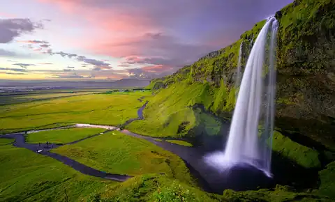
A 60-metre curtain of the Skógá dropping off a former sea cliff beside the Ring Road — the anchor of Iceland's South Coast waterfalls, with Seljalandsfoss half an hour west and more than twenty further falls waiting up the staircase above it.
Full guide Checked September 2026 by David Bussell · 61 sources
Skógafoss falls 60 metres in a single, almost square sheet about 25 metres wide, off an escarpment that was the Icelandic shoreline until the land rose and the coast retreated roughly five kilometres south. That is the whole trick of the place: a river from the pass between two glaciers, Eyjafjallajökull and Mýrdalsjökull, reaches an old sea cliff and simply steps off it onto a flat gravel plain. The spray is heavy enough that on any sunny day a rainbow — often a double — hangs in front of the curtain, and heavy enough to soak you at the base within a minute.
You experience it in two halves. The base is a flat walk across the plain to the edge of the plunge pool, close enough to feel the noise in your chest; since January 2026 cars stop at a new paid car park about 500 metres away, outside the protected natural monument. The top is 527 metal steps up the east side to a platform that hangs over the lip, looking down the river and across the lowlands to the sea. Beyond it, a path follows the Skógá upstream past waterfall after waterfall — the start of the Fimmvörðuháls trail over the pass to Þórsmörk.
Skógafoss is the obvious base for the whole South Coast waterfall run. Seljalandsfoss, the one you can walk behind, and Gljúfrabúi, tucked inside a gorge, are 30 km west; Kvernufoss hides in a ravine a short walk from the Skógar Museum; Sólheimajökull's glacier tongue and the DC-3 wreck on Sólheimasandur are within 15 minutes east; and Vík, the ice caves under Mýrdalsjökull and Reynisfjara's black beach are half an hour beyond. Stay a night in Skógar and you get the falls empty at dawn, before the Reykjavík day tours arrive.
Skógar, Route 1 — 30 km east of Seljalandsfoss
The bigger, louder, simpler of the two: one wide curtain you approach head-on across flat gravel, with a 527-step staircase to a platform above the lip and a riverside path beyond it that keeps producing waterfalls for kilometres. You can't walk behind it, but you can stand in the spray at the base, climb for the view down to the sea, and spend anything from twenty minutes to a full day here. Kvernufoss and the Skógar Museum are a few minutes' walk from the village.
Route 249, just off Route 1 — 30 km west of Skógafoss
A 60-metre ribbon rather than a curtain, dropping over an overhang so that a loop path runs through the cave behind it — the one South Coast fall you can walk all the way round, and the one where you'll get the wettest. A few hundred metres north along the cliff, Gljúfrabúi drops into a narrow gorge you enter by stepping or wading up a stream into a mossy chamber. The behind-the-falls path closes when it ices over, typically in the depths of winter.
Do both — they are 25 minutes apart on the same road, and every South Coast tour stops at each. If you only have time to linger at one, make it Skógafoss: the climb and the Waterfall Way turn it into a half-day, while Seljalandsfoss and Gljúfrabúi are done well in an hour. Bring a waterproof layer for Seljalandsfoss regardless.
June to August for the trail above the falls and endless light; September for thinner crowds with aurora returning; a clear February or March night if the aurora over the falls is the point.
Skógafoss flows hard all year; the real variables are light and ice. Summer gives near-endless daylight and the only window for the Fimmvörðuháls crossing, while winter shrinks the day to four or five hours and can close the staircase and the path behind Seljalandsfoss.
Daylight until close to midnight, snowmelt from both glaciers keeping the Skógá full, and the whole trail above the falls open — this is the only season for the full Fimmvörðuháls crossing, with huts staffed and the Highland Bus running from Þórsmörk. It is also peak coach season: from roughly 10:00 to 17:00 the base is crowded, so come early or late.
Tour traffic thins noticeably, flow stays strong, and by September the nights are dark enough for aurora again. Snow can linger high on the Fimmvörðuháls pass into June and returns from mid-September, so treat the lower Waterfall Way as the realistic hike and the full crossing as summer-only. Weather swings fast: calm and bright one hour, gale and sleet the next.
The falls never stop, but spray glazes the rocks, the staircase and the path behind Seljalandsfoss, and either can be roped off when icy. December daylight runs to roughly four or five hours. In exchange you get the falls nearly to yourself, snow on the escarpment, and dark skies — Skógafoss sits well away from any town lights and is one of the South Coast's classic aurora foregrounds.
Skógafoss throws so much spray that a rainbow appears on nearly every sunny day — often a double, sometimes arcing almost to the ground at your feet. The falls faces roughly south, so stand at the base with the sun behind you. You don't need to time it precisely; you need sun, which on Iceland's South Coast is the harder part.
Prices are 2025/2026 advertised rates in ISK or USD from operator, municipal and booking-platform listings, converted to USD at roughly 121 ISK/USD; they move with season, group size and exchange rates and should be treated as a planning guide rather than a quote.
Climb the 527 steps on the east side to the platform over the lip, then keep going: a path follows the Skógá upstream through a narrow canyon past a chain of falls — Hestavaðsfoss, Fosstorfufoss, Skálabrekkufoss and many more unnamed ones — each different in shape from the last. Walk as far as you like and turn round; there is no need to commit to the full Fimmvörðuháls crossing to see most of the waterfalls. Grippy boots matter, since the path is muddy and exposed in places.
Year-round for the stairs when not iced over; upstream path best June – September
No booking needed.
Iceland's best-known day hike runs from Skógafoss up the Skógá past more than twenty waterfalls, crosses the 1,000-metre pass between two glaciers beside the Magni and Móði craters from the 2010 eruption, then drops steeply into the birch valley of Þórsmörk. Weather on the pass turns fast and fog is common; the Baldvinsskáli hut (16 beds, about 17,000 ISK / $140 a night, no drinking water) splits it into two days. Read the 2026 warning below before you go.
July – August for the guided day hike; trail generally late June – mid-September
Sólheimajökull, a tongue of the Mýrdalsjökull ice cap, ends about 10 km east of Skógafoss, and it's the easiest real glacier walk in the south to reach by car. Crampons, harness and ice axe are supplied; guides lead you past moulins, ridges and ash-banded crevasses. The glacier has retreated sharply in recent decades and the walk-in from the car park lengthens every year. Parking at the glacier is about 750 ISK (~$6).
Year-round
The ice cave that runs in summer as well as winter: a super-jeep from Vík out across the Mýrdalssandur outwash plain to the edge of Mýrdalsjökull, then a short, easy walk into a cave of blue ice striped with black ash layers from past Katla eruptions. Helmet, headlamp and crampons are supplied. The cave shape changes season to season as the ice melts and moves, so the photos you see online won't match exactly.
Year-round
Doing this one? Check your travel insurance covers adventure activities before you go — SafetyWing is one option.
Thirty kilometres west of Skógafoss, Seljalandsfoss drops 60 metres over an overhang, and a loop path takes you through the cave behind it — waterproofs essential, since you will get soaked. Then walk a few hundred metres north along the cliff to Gljúfrabúi, which falls inside a narrow gorge: step (or wade) up the stream through a slot into a mossy chamber with the waterfall pounding onto a boulder in the middle. Summer evenings put the low sun straight through the curtain.
Year-round; rear path at Seljalandsfoss closes when icy
No booking needed.
The quiet counterpart to Skógafoss, about two kilometres east of it: a 30-metre fall at the head of the Kvernugil ravine, reached by an easy path from the Skógar Museum car park. Like Seljalandsfoss, a slippery track leads into the hollow behind the water, but with a fraction of the crowd. Go late in the day when the coaches have moved on, and expect the rocks behind the fall to be wet or iced whatever the season.
Year-round; crampons useful in winter
No booking needed.
The bare fuselage of a US Navy Douglas C-117 — a Super DC-3 — that crash-landed on the black sand in November 1973, with everyone aboard surviving. It lies about 4 km from the car park off Route 1, some 6 km east of Skógar. The walk takes 40–50 minutes each way across featureless sand; the shuttle cuts it to minutes. In January 2020 two visitors died of exposure on this walk, so don't attempt it in bad weather or failing light.
Year-round, daily roughly 10:00–17:00, daylight permitting
Pay on the day — nothing to book in advance.
A two-minute drive from the falls and far better than a village museum has any right to be: a folk museum of around 15,000 objects, an open-air collection of turf houses and a wooden church, and a transport and technology museum. It also holds the old church door ring said to come from the treasure chest the settler Þrasi Þórólfsson hid behind Skógafoss. Freya Café is on site, and the Kvernufoss path starts from the car park.
Year-round; 09:00–18:00 June – August, 10:00–17:00 September – May
Pay on the day — nothing to book in advance.
The standard way to see Skógafoss without a car: Seljalandsfoss, Skógafoss, Sólheimajökull, Reynisfjara and Vík in one long day, with around 30–60 minutes at each stop. That is enough for the base of Skógafoss but rarely for the staircase and the falls above it. Pick a small-group version if you can, and in winter expect the short daylight to squeeze the later stops.
Year-round
A 25-metre concrete pool built into the valley wall under Eyjafjallajökull in the 1920s, fed by a hot spring and reached by a river-side walk with a stream crossing, about 20 km west of Skógafoss. Water runs from around 35°C at the inlet to 25°C at the far end. There are no showers, no staff and no water treatment — algae builds up in summer and the changing shed is basic. Go for the setting, not the facilities.
Year-round, weather permitting
No booking needed.
An interactive volcano and earthquake exhibition in Hvolsvöllur, 30 minutes west of Skógafoss, that explains what you're driving past: the Eyjafjallajökull eruption of 2010 that grounded European air travel, the Katla volcano under Mýrdalsjökull, and the Hekla cone on the horizon. The obvious rainy-day stop on the South Coast, it also tracks live seismic activity across the region, which makes it worth a look before a glacier or ice-cave trip.
Year-round; 08:30–19:00 June – August, 08:30–17:00 September – May
Pay on the day — nothing to book in advance.
On 25 August 2026, Ferðafélag Íslands, Útivist, the Dagrenning rescue team and the Icelandic Tourist Board jointly advised people not to hike Fimmvörðuháls: glacier retreat has opened new ravines and crevasses and exposed steep scree between the Baldvinsskáli and Fimmvörðuskáli huts, and heavy rain had made parts of the route impassable. On 2 September Ferðafélag Íslands published a detour — a blue-marked route along the track between Baldvinsskáli and the Skógá bridge, with numbered GPS posts — as the recommended autumn line. The trail was never formally closed, but the organisations now treat it as a serious mountain journey rather than a maintained path. The warning concerns the high section; the Waterfall Way directly above Skógafoss wasn't mentioned. Check fi.is and safetravel.is before starting.
Most visitors pass through on a day tour, but a night in Skógar itself — or in Vík or Hvolsvöllur — gets you the falls without the coaches and a real chance at aurora from October to April.
Run by EJ Hotels, with rooms decorated by local artists and a bistro and bar whose windows face the falls. The closest hotel bed to Skógafoss: walk out after dinner or before breakfast and have the base to yourself.
A 12-room, 3-star house in Skógar village with an à la carte restaurant built around local, seasonal produce and a fireplace lounge. Small, quiet and walkable to both Skógafoss and the Skógar Museum.
Open all year, first come first served, with toilets, paid hot showers (400 ISK) and electric hook-ups (1,200 ISK). Tents within sight of the falls — but only two toilets and two showers for a busy summer field.
A small, minimalist country hotel with floor-to-ceiling windows on the glacier and the Atlantic, a restaurant built on local ingredients, and a private sauna. Holds a Michelin Key and sits between Seljalandsfoss and Skógafoss.
A modern 73-room hotel on the edge of Vík, opened in 2018, with Drangar restaurant and a cocktail bar. A practical base for the Katla ice cave, Reynisfjara and Dyrhólaey, with Skógafoss half an hour west.
A small farm-hostel with views of the Reynisdrangar sea stacks, a guest kitchen, family rooms and a resident flock of chickens and ducks. Closes every year from 5 to 31 January.
A 66-room family-run hotel in business since 1984, with hot tubs, a restaurant and bar, and triple and family rooms. Well placed between Seljalandsfoss and Skógafoss, next to the LAVA Centre.
A log-built luxury lodge on the Rangá river with its own observatory, geothermal hot tubs and an aurora wake-up call. The South Coast's upscale aurora base, though it puts Skógafoss well down the road.
Search all Skógar, Iceland accommodation
Iceland's only major international gateway, about 50 km southwest of Reykjavík and roughly 200 km / 2.5 hours from Skógafoss by road via Route 1. Direct flights from North America and across Europe on Icelandair, Play and seasonal carriers.
Keflavík is the only realistic way in; every route to Skógafoss runs through or around Reykjavík and then east along the Ring Road via Selfoss and Hvolsvöllur.
Route 1 is paved all the way and kept open in winter, but the stretch under Eyjafjöll between Hvolsvöllur and Vík is notorious for gusts strong enough to damage car doors and push campervans off the road; check road.is and safetravel.is before every winter drive. Without a car, Strætó's route 52 (Reykjavík–Höfn) stops at Hvolsvöllur, Skógar and Vík four days a week — Tuesday, Thursday, Friday and Sunday — at 7,200 ISK (~$60) from Mjódd to Skógar; it does not stop at Seljalandsfoss. Fimmvörðuháls hikers get back from Þórsmörk on the summer Highland Bus (roughly 1 June – 24 September 2026), sold by Icelandia and Trex.
EES and ETIAS timelines have shifted several times through 2025–2026 and are likely to shift again; check the EU's official ETIAS site or your carrier shortly before you fly rather than relying on this guide's date.
 This waterfall
Skógafoss
Iceland
Height60 mWidth25 m
 Most similar
Seljalandsfoss
Iceland
Height60 mWidth—
Also a plunge waterfall, of similar height and in Iceland too
 Largest curtain
Victoria Falls
Zimbabwe · Zambia
Height108 mWidth1,708 m
Largest single sheet of falling water
 Tallest on earth
Angel Falls
Venezuela
Height979 mWidth—
 Widest on earth
Khone Phapheng Falls
Laos
Height21 mWidth10,783 m
Measured across the whole multi-channel system
Angel Falls is 16× taller than Skógafoss. Victoria Falls is 1.8× taller and 68× wider. Khone Phapheng Falls is 431× wider. Tallest · widest lists.
 1:36
 10:03
 7:47
Chosen from YouTube; videos belong to their creators and play from YouTube's privacy-enhanced player.
Walking guide
Paddy Dillon · 2015
Cicerone routes incl. the Fimmvörðuháls trek from Skógafoss, Skaftafell walks to Svartifoss and the Jökulsárgljúfur canyon by Dettifoss.
Guidebook
Lonely Planet · 2026
Newest Lonely Planet edition: Ring Road planning, road and weather advice, and practical detail for every major Icelandic waterfall.
Guidebook
Rough Guides · 2025
Current Rough Guide with region-by-region coverage of the south coast, Mývatn area, Snæfellsnes and Vatnajökull.

Guidebook
DK Eyewitness · 2024
Map-heavy illustrated guide, handy for picturing the Golden Circle and south-coast falls before you drive them.
527 metal steps, climbing the east side of the falls to a viewing platform over the lip. Most people take 15–25 minutes up with stops. The treads are scored for grip and there's a handrail, but the stairs are steep, get slick with spray, and can be closed when iced over in winter.
Entry is free, but parking isn't. Since May 2025 a camera system charges 1,000 ISK (~$8) per car per 5 hours, paid through Parka, and since January 2026 the car park sits about 500 metres from the falls, outside the protected area. Unpaid fees are billed to the car's owner — your rental company — with a penalty.
No. There's no path behind the curtain, and the base is as close as you can get — close enough to be soaked. For walking behind a waterfall, go to Seljalandsfoss 30 km west, or to Kvernufoss, a quieter fall two kilometres east of Skógafoss reached by a one-hour return walk from the Skógar Museum.
About 155 km from Reykjavík, roughly two hours' driving on Route 1, and 200 km or about two and a half hours from Keflavík airport. Seljalandsfoss is 30 km west, around 25 minutes. Vík is roughly 30 km east, which is why most people see all three in one South Coast day.
Only with real care. In August 2026 Iceland's hiking and rescue organisations advised against the crossing after glacier retreat opened crevasses and ravines on the high section; in September a blue-marked detour was published as the recommended route. The trail is also a summer-only route, roughly late June to mid-September. The lower Waterfall Way above Skógafoss makes an excellent out-and-back instead.
Whenever the sun is out. The spray is so dense that a single or double rainbow forms in front of the falls on most sunny days; stand at the base with the sun behind you. The limiting factor is the weather — the South Coast is one of the cloudiest, wettest parts of Iceland.
Yes, from roughly September to mid-April, on clear nights with enough solar activity. Skógafoss has little light pollution and faces south, so the aurora usually appears to the north over the escarpment, above the falls. Stay in Skógar or Vík rather than driving from Reykjavík, and check the cloud and aurora forecasts.
Not yet. Iceland is in the Schengen Area and most Western passport holders enter visa-free for up to 90 days in any 180-day period. ETIAS, the planned €20 pre-travel authorisation, has been delayed repeatedly through 2026 with no confirmed launch date — check before you fly rather than assuming it's live.
Skógafoss is in Iceland (Southern Iceland), inside Skógafoss Natural Monument. The nearest base is Skógar and the closest airport is KEF. Its coordinates are 63.5321, -19.5114.
Yes. Skógar has a simple campsite near the falls (about 2,200 ISK, roughly $18, per adult per night in 2026), and it's the classic way to have the falls to yourself at dawn. Wild camping in a vehicle or tent outside designated sites isn't allowed along the South Coast.
It means 'the waterfall of Skógá' — the river Skógá, which takes its name from the farm and hamlet of Skógar ('forests'). The falls sit at the edge of the former coastline above the village.
Prices, fees and entry rules change. We re-check full guides regularly; spotted something out of date? Tell us.
Nearby

Írárfoss is a waterfall in Iceland.
One of the few waterfalls walkable on all sides

Gluggafoss is a waterfall in southern Iceland, specifically in the Fljótshlíð area. As the most prominent…

Þjófafoss aˌfɔsː] , "thieves' waterfall"; also Thjofafoss) is located on the river Þjórsá on the east side of…