
About this place
I Am the Grand Canyon: The Story of the Havasupai People
Stephen Hirst · 2007
History of the Havasupai, whose reservation holds Havasu Falls; useful context before hiking into Supai village.

United States · Arizona
A turquoise creek falling through red rock deep in a side canyon of the Grand Canyon, reachable only on foot, by mule or by helicopter, and only with a permit bought directly from the Havasupai Tribe. No day hikers, no drive-up view.
Full guide Checked September 2026 by David Bussell · 16 sources
Havasu Creek runs an improbable blue-green through bone-dry desert canyon, fed by springs so loaded with dissolved limestone that the water lays down travertine — the same mineral that builds cave formations — as fast as it flows. That travertine terraces the creek into staircases of pools and drops, and Havasu Falls itself is the postcard version: a single 30-metre chute pouring into a wide turquoise pool ringed by cottonwoods, a few hundred metres above the campground.
The falls sit inside the Havasupai Indian Reservation, a sovereign nation whose only village, Supai, is at the bottom of the canyon and is still resupplied by mule train and helicopter rather than road — the last place in the United States where mail is delivered that way. Getting there means an 8-mile hike from the rim down to Supai, then 2 more miles to the campground and the falls, past a sequence of drops — Navajo, Fifty Foot, Havasu, Mooney, Beaver — each with its own character, Mooney requiring a chain-and-ladder descent down a travertine cliff to reach the bottom.
This is not a sightseeing stop. The Havasupai Tribe sells a fixed product: a 3-night, 4-day permit, camping or lodge, hiking in and out under your own power (or paying for a mule or a helicopter seat). There is no day-use gate and no shortcut. What you get for the effort is genuinely singular water in a genuinely remote canyon, run entirely by the people who live there.
Nothing here is sold through tour sites. Havasu Falls works on official permits only — book with HavasupaiReservations.com, and treat anyone else selling permits as a reseller.
The Havasupai Tribal Council has kept a standing moratorium on outfitter and guide licenses for the reservation, so no licensed company sells a guided trip, gear-included package or permit-inclusive tour into Havasu Falls, and any listing that claims to include a Havasupai permit is either reselling a permit it isn't supposed to, or lying. The only legitimate way in is to hold your own campground or lodge reservation, bought directly at HavasupaiReservations.com. Formal permit transfers were also discontinued starting with the 2026 system — if your plans change, the tribe's own cancellation policy (partial refund with 90+ days' notice, none inside that window) is the only official route, not a resale board.
~1.5 km before the campground, just south of Supai
The creek's course shifted in a 2008 flood, and what locals now call Navajo Falls is a wide, braided drop reached by a short side trail off the main route, with the smaller Fifty Foot Falls (sometimes called Little Navajo) just upstream. Neither is on the direct trail — both need a short detour — and both are usually quiet because most hikers walk straight past on day one, heads down, aiming for camp.
At the north end of the campground
A single 30-metre chute over a travertine lip into a wide, genuinely turquoise pool with a sand beach and rope swing. It sits right where the campground begins, so it is the falls you wake up next to, swim in before breakfast, and photograph in the low morning light before the day-trippers from camp arrive. The colour is at its most intense in full sun, closer to green in shade.
~1 km south of the campground
At roughly 60 metres, Mooney is the tallest fall in the canyon and the hardest to reach: the trail drops through two hand-carved tunnels in the rock, then a near-vertical travertine face fitted with iron stakes, chains and short ladder sections, wet and slick with spray the whole way down. It is not optional if you want Beaver Falls — this is the only route past — and it is genuinely exposed. Gloves help. Go slowly and let faster hikers pass at the tunnel mouths.
~5 km (3–4 hr round trip) beyond Mooney
A series of smaller stepped travertine terraces and pools spread across a wide bend in the creek, reached by a route that crosses the water several times and includes one short ladder. It takes a half-day round trip from camp and is usually the destination on the one full day most 3-night permits leave free — quieter than Havasu Falls and, by most accounts, the best actual swimming of the trip.
You cannot choose one — the permit gets you the whole canyon, and the falls are effectively unlocked in sequence as you walk in. Budget the arrival day for Navajo and Havasu Falls, one full day for the round trip to Mooney and Beaver Falls, and treat the third day as recovery before the hike out.
October is the general favourite — warm enough to swim, cool enough to hike, past monsoon season — with February–April a close second if you don't mind cold nights and skip the swim.
Heat, not water level, is what plans your trip. The canyon floor runs far hotter than the rim, there is no shade on most of the trail, and the reservation is closed outright for two months every winter.
The most popular window and the reason permits vanish fastest for these dates. February and March are cool for hiking but often too cold to swim comfortably; by April, highs reach the high 20s°C (mid-70s to 80s°F) with cold nights. This is when the reservation reopens for the season, so February permits are also the first ones released each cycle.
June through August routinely tops 38–41°C (100–105°F) on the canyon floor, with no shade for most of the 16 km hike — this is the season most heat-related rescues happen. July through early September is also monsoon season, with sudden, violent thunderstorms upstream that can flash-flood the creek with little warning at camp, even under a clear sky overhead.
Widely rated the best window after spring: highs easing into the high 20s°C (low 80s°F) by October, monsoon risk fading, water still warm enough to swim, and noticeably thinner crowds than spring. The reservation typically closes for the season in late November.
The Havasupai Reservation does not sell permits and is closed to tourists for these two months. This is not a soft off-season — no permits exist for these dates, and the tribe uses the window for village maintenance and its own off-season.
Unlike a park with a year-round gate, Havasupai runs on a season: it typically opens in early February and closes in late November to early December, and the whole calendar year's permits go on sale in a single rush at the start of that window. Plan around the sale date, not around when you'd ideally like to travel.
Permit and service prices are the Havasupai Tribe's published 2026-season rates in USD, confirmed against the tribe's own reservation platform and its help centre; pack-mule and helicopter fares are secondary-sourced and worth reconfirming at booking, as noted in the callout and unverified list below.
The core product: a permit to camp along Havasu Creek between Havasu and Mooney Falls, first-come site selection along a roughly 1.5 km stretch of campground, composting toilets, and a spring at the south end for drinking water (still worth treating or filtering). This is not a booking for a tour — it is the tribe's own reservation system, and it is what gets you past the checkpoint in Supai.
February – late November (reservation open season)
A plain, air-conditioned motel building in Supai village itself, 2 miles short of the campground and the falls — so you still walk 4 miles round trip to Havasu Falls each day you want to swim there. No restaurant on site; buy food at the small village store and café. The only non-camping option, and it sells out just as fast as campground dates.
February – late November
8 miles of switchbacks and then open wash to Supai village, then 2 more flat miles to camp — about 16 km and 600 m of net elevation loss on the way in, all of it regained on the way out. There is essentially no shade on the whole route. Fill water at the hilltop; the next reliable source is Supai.
Best before 7am start in warm months
No booking needed.
Carries your gear, not you — riding is not offered to tourists. Bags must be soft-sided duffels, 32 lb (14.5 kg) max each, up to 4 per animal, no coolers, booked at least 72 hours ahead and labelled with your confirmation code. Animal-welfare groups have documented serious problems with overloading and heat stress on this trail in past years; the weight caps and inspection rules exist because of that scrutiny, and travellers who use the service should stick strictly to the limits.
Year-round while the reservation is open
No booking needed.
Flies between Hualapai Hilltop and Supai village only — you still walk or mule the 2 miles from village to campground. Tribal members, tribal business and cargo board first; tourists fill remaining seats on a walk-up or day-ahead sign-in basis, and there is no guarantee of a seat on any given day. Weather, mechanical issues and tribal needs ground it without notice, so never plan a trip assuming you'll fly — always be ready to hike.
Sundays and Fridays historically, though days vary — verify before relying on it
Pay on the day — nothing to book in advance.
The wide travertine-rimmed pool below the main falls is the classic swim — a sand beach, a rope swing, and water that stays a startling blue-green even in shade. Busiest midday when day-camp hikers wander down; quietest at dawn.
Warmest May – October; cold outside that
No booking needed.
Two tunnels blasted through rock, then a near-vertical travertine face with iron stakes, chains and short ladder rungs, spray-slicked most of the way. It is the one section of this trip that reads as a genuine via ferrata rather than a walk, and it is the only way through to Beaver Falls and the Confluence.
Year-round, more treacherous when wet or crowded
No booking needed.
Past Mooney Falls, the trail crosses the creek repeatedly through a lush stretch of canyon to a wide series of stepped travertine pools. Most 3-night permits build their one full free day around this hike; go early to beat the heat on the return climb out of the Mooney descent.
Year-round the reservation is open
No booking needed.
For strong hikers only, roughly 6 km beyond Beaver Falls to where Havasu Creek meets the Colorado River — turquoise water hitting the Colorado's green or brown, depending on releases upstream. This turns your one free day into a genuinely full one; carry more water and start before sunrise in the warmer months.
Cooler months strongly recommended
No booking needed.
There is no hotel market at the falls themselves — you are either in the campground or the lodge, both booked as part of your permit — so the choices that matter are where you sleep the night before the hike.
Tent sites strung along roughly 1.5 km of creek, first-come first-served on arrival. Composting toilets, one spring for drinking water at the south end, no campfires, no cell signal.
Plain motel rooms with beds and air conditioning, 2 miles short of the falls themselves. The only roof-and-bed option, and the only one where you don't need to carry a tent down the trail.
Tribally owned by the neighbouring Hualapai Tribe, about an hour's drive from Hualapai Hilltop. Restaurant on site, the most reliable base for an early trailhead start.
The closer of the two common overnight stops — roughly an hour from the trailhead — and, at points, used as an official permit check-in location. Built around the show cave next door.
The nearest town with real hotel supply and services, about 90 minutes from the hilltop. Fuel up and buy last-minute gear here — nothing similar exists closer to the trailhead.
A smaller, kitschier Route 66 stop between Kingman/Flagstaff and the Indian Route 18 turn-off, roughly 45–60 minutes from the hilltop.
Search all Peach Springs AZ accommodation
~195 mi / ~3.5 hr drive to Hualapai Hilltop via Kingman. The most common gateway — cheap flights, big rental-car market.
~245 mi / ~4.5 hr drive. More direct flight options for the US East Coast; longer drive than from Las Vegas.
~170 mi / ~3.5 hr drive via I-40 west. Fewer flights, but closest to Grand Canyon South Rim if combining trips.
Las Vegas is the dominant gateway for both domestic and international connections; Phoenix is the alternative if your flights route through there instead.
From I-40 near Peach Springs, Indian Route 18 runs about 60 miles north with no fuel, no services and patchy-to-no cell signal, dead-ending at the Hualapai Hilltop trailhead parking lot. There is no camping at the hilltop the night before unless you're starting a pre-dawn hike from your car — most people stay in Peach Springs or Seligman and drive up in the dark to start hiking at first light. Parking is limited and fills for busy weekends.
 This waterfall
Havasu Falls
United States
Height30 mWidth—
 Most similar
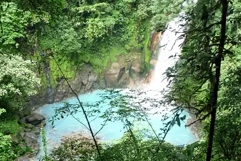
Rio Celeste Falls
Costa Rica
Height30 mWidth—
Also a plunge waterfall, of similar height and in Costa Rica
 Largest curtain
Victoria Falls
Zimbabwe · Zambia
Height108 mWidth1,708 m
Largest single sheet of falling water
 Tallest on earth
Angel Falls
Venezuela
Height979 mWidth—
 Widest on earth
Khone Phapheng Falls
Laos
Height21 mWidth10,783 m
Measured across the whole multi-channel system
Angel Falls is 33× taller than Havasu Falls. Victoria Falls is 3.6× taller. We don't have a reliable crest width for Havasu Falls yet, so it is left off the width chart. Tallest · widest lists.
 17:28
 4:55
 20:39
Chosen from YouTube; videos belong to their creators and play from YouTube's privacy-enhanced player.
About this place
Stephen Hirst · 2007
History of the Havasupai, whose reservation holds Havasu Falls; useful context before hiking into Supai village.
Guidebook
Lonely Planet · 2024
Latest Lonely Planet Grand Canyon guide, covering rim logistics and the Havasupai reservation's permit-only trail.
History & travel
Michael P. Ghiglieri and Thomas M. Myers · 2012
Sobering accounts of Grand Canyon accidents, including heat and flash-flood lessons relevant to the Havasu hike.
No. Tribal law requires an overnight permit for anyone entering the reservation past the checkpoint in Supai — there is no day-use option, and rangers check wristbands. Every visit is a minimum 3-night, 4-day commitment, camping or at the lodge.
Campground permits are $455 per person for the mandatory 3 nights. Lodge rooms are $2,277 per room for 3 nights, sleeping up to four people — about $569 per person at full occupancy. An optional early-access sale window carries an additional per-person fee.
The 2026 season's early-access sale opened 21 January 2026 at 8am Arizona time for an added fee, with general public sale on 1 February 2026 at 8am Arizona time, through HavasupaiReservations.com. Popular dates, especially spring and fall weekends, sell out within the sale's opening hours.
Not officially. The tribe discontinued its lottery and transfer-board system starting with the 2026 booking platform, and permits are stated to be non-transferable. Cancel 90 or more days before your date for a 50% refund of the permit fee; inside that window there is no refund. Treat any third-party resale as unofficial and risky.
Yes, as of the most recent official update the reservation is operating normally with both campground and lodge permits available. The area has closed before — five weeks after a fatal August 2024 flash flood, and again briefly after flooding in June 2025 — so it is worth checking the tribe's own status page shortly before you travel.
About 16 km (10 miles) each way with roughly 600 m (2,000 ft) of net elevation change, almost entirely without shade. Most people manage it in 6–10 hours with a loaded pack. The climb out is harder than the descent in, and summer heat regularly pushes past 38°C (100°F) on the canyon floor.
Airwest Helicopters flies tourists between Hualapai Hilltop and Supai village on a limited schedule, historically Sundays and Fridays, but tribal members and cargo board first and there is no guaranteed seat. Budget around $300 per person each way plus a luggage fee, cash preferred, and always be prepared to hike instead.
No. The Havasupai Tribal Council maintains a moratorium on commercial outfitter and guide licenses on the reservation, so no legitimate tour operator sells a package that includes a Havasupai permit. You book directly with the tribe or you don't go.
Havasu Falls is in United States (Grand Canyon, Arizona), inside Havasupai Indian Reservation. The nearest base is Supai. Its coordinates are 36.2551, -112.6975.
No. Havasu Falls is in Havasu Canyon on the Havasupai Indian Reservation, a side canyon of the Grand Canyon in northern Arizona. Lake Havasu State Park is a reservoir park on the Colorado River near Lake Havasu City, several hours' drive away, and has no waterfall of its own.
Prices, fees and entry rules change. We re-check full guides regularly; spotted something out of date? Tell us.
Nearby

Bonita Falls are a set of waterfalls in the San Bernardino National Forest, formed by unnamed tributary to…

Waterwheel Falls is a waterfall in the Sierra Nevada of California, located in Yosemite National Park. It is…
 UNESCO
Upper anchor of Yosemite's famous Mist Trail

Snow Creek Falls is a long series of cascades located in Yosemite National Park toward the eastern extent of…