
Walking guide
Walking and Trekking in Iceland
Paddy Dillon · 2015
Cicerone routes incl. the Fimmvörðuháls trek from Skógafoss, Skaftafell walks to Svartifoss and the Jökulsárgljúfur canyon by Dettifoss.

Iceland · Diamond Circle
A 44-metre wall of grey glacial water, 100 metres wide, pouring into the Jökulsárgljúfur canyon in North Iceland — the centrepiece of a run of four waterfalls and the horseshoe cliffs of Ásbyrgi, all on the paved Diamond Circle loop from Akureyri.
Full guide Checked September 2026 by David Bussell · 36 sources UNESCO World Heritage
Dettifoss is not pretty in the way Iceland's ribbon falls are. The Jökulsá á Fjöllum arrives from the northern edge of Vatnajökull thick with silt, the colour of wet cement, and drops 44–45 metres across a ledge roughly 100 metres wide at an average of about 193 cubic metres a second. The result is a churning, roaring slab of water rather than a curtain, with a spray column visible from kilometres away across bare lava desert. Put a hand on the rock near the edge and you can feel it vibrate. The falls are also on the move, eating back into the canyon by around half a metre a year.
The river is the border between two sides that never meet: there is no bridge anywhere near the falls, so you choose a bank. The west bank, reached by the paved Road 862, has the bigger car park, toilets and a one-kilometre path to platforms that look across and slightly down into the spray, with Selfoss a short walk upstream. The east bank, at the end of the gravel Road 864, puts you on open rock right beside the drop, drier and closer, but only between early summer and the first autumn snow. Downstream, Hafragilsfoss drops another 27 metres into the canyon.
Dettifoss sits in the Jökulsárgljúfur section of Vatnajökull National Park, and it anchors the Diamond Circle: a loop of roughly 250 km from Akureyri taking in Goðafoss, Lake Mývatn's craters and steam vents, Dettifoss, Selfoss and Hafragilsfoss, the horseshoe canyon of Ásbyrgi, and the whale-watching harbour at Húsavík. You can drive it in a long summer day, but two or three nights let you walk the canyon, see both banks of Dettifoss, and add whales and a geothermal soak.
Road 862 — paved, from the Ring Road east of Mývatn or from Ásbyrgi
The side most people see, and the only one you can reach outside summer. A paved road, a large car park with toilets, and a marked path of about a kilometre to viewing platforms that look across the full width of the falls. The spray usually blows this way, so expect to get wet and to find the rocks slick. Continue upstream along the rim and Selfoss, a broad, low 10-metre horseshoe, fans out across the river — the easy two-for-one that the east bank can't match.
Road 864 — gravel, north from the Ring Road towards Kópasker
A slower drive on a potholed gravel road buys you a different Dettifoss: a short walk of about ten minutes from the car park to open basalt right beside the drop, often upwind of the spray, with a head-on view of the whole face and the grey river boiling into the canyon below. Fewer railings, fewer people. A separate turn-off leads to a viewpoint above Hafragilsfoss, far easier than reaching it from the west. The road closes when autumn snow falls and reopens only once the spring mud dries.
If you only do one side, do the west: it's paved, it's open far more of the year, it has Selfoss, and it fits the Diamond Circle loop. Between June and early autumn, with time and a car that handles gravel, add the east bank for the closer, drier, head-on view and Hafragilsfoss — the two car parks are more than an hour apart by road.
June to August for both banks and the full Diamond Circle; September for quieter trails with aurora returning; November to April only if you're content with the west bank, a super-jeep, or a turned-back car.
The river runs hard all year; what changes is which roads are open. Road 864 to the east bank is a summer-and-autumn road only, and even the paved Road 862 to the west bank gets limited winter service, so from November to April reaching Dettifoss depends on the day's weather.
Both banks open, snowmelt off Vatnajökull pushing the flow to its fullest, and daylight that barely ends. It's the season for the two-day Canyon Trail to Ásbyrgi, for whales and puffins off Húsavík, and for camping in Ásbyrgi and Vesturdalur. It is also when tour coaches and campervans fill the west-bank car park from late morning, so aim for early or late in the long evenings.
Tour traffic drops sharply, the birch in Ásbyrgi turns, and by mid-September the nights are dark enough for aurora over the canyon. Road 864 stays open until the first real snowfall, which in some years comes in October and in others earlier, so treat the east bank as a bonus rather than a plan. Ásbyrgi's campsite runs to the end of October; Gljúfrastofa visitor centre keeps 10:00–17:00 daily hours.
Dettifoss half-frozen and framed in ice, with almost nobody there. The catch is getting in: Road 864 is shut, and Road 862 gets only limited snow clearing — Visit North Iceland says it isn't maintained from January to the start of April — so it can be closed for days at a time. Most winter visitors go with a super-jeep tour from Mývatn or Akureyri. Goðafoss, Mývatn and Húsavík stay reachable on the Ring Road and Route 85 through winter.
Snowmelt starts to lift the river, the Ásbyrgi campsite opens on 15 May, and the Mývatn and Húsavík sights are back in full swing. But this is the awkward month for Dettifoss itself: Road 864 usually stays closed until the end of May or into June while the gravel dries, and trails in the canyon are wet, muddy or still under snow. Fine for the west bank; check before counting on the east.
On a sunny afternoon, the sun sits behind anyone standing on the west bank, and the spray column in front of them often carries a rainbow arching over the canyon. The same spray is why west-bank visitors come back damp and why the platforms and rocks are slick in any season — and glazed with ice from autumn onwards. On the east bank you are usually upwind and drier, with the better morning light.
Prices are 2025/2026 advertised rates in ISK from operator, national park and booking-platform listings, converted to USD at roughly 121 ISK/USD; they move with season, group size and exchange rates and should be treated as a planning guide rather than a quote.
The classic walk: about a kilometre from the car park across lava and boulder fields to the platforms overlooking Dettifoss, then upstream along the canyon rim to Selfoss, a wide, broken 10-metre horseshoe that spills across the river in dozens of separate chutes. The national park rates it easy, but the rocks near the edge are wet with spray and uneven, and there are drops with no barrier once you leave the platforms. Waterproofs help.
Year-round when Road 862 is open; icy October – April
No booking needed.
Drive the gravel Road 864 north from the Ring Road and walk ten minutes to the rim right beside the falls, where you look straight across the face of Dettifoss rather than at an angle. Then take the short spur to the viewpoint above Hafragilsfoss, a 27-metre fall set deep in the canyon with red and black cliffs either side. Keep well back from the edges here — there are few railings, and the rock can be loose.
Roughly June until the first autumn snow (Road 864 open)
No booking needed.
The best way to understand the canyon: two days on foot from Dettifoss down the west side of Jökulsárgljúfur to Ásbyrgi, past Hólmatungur's springs and the basalt formations of Hljóðaklettar at Vesturdalur. Camping is only allowed at the park's designated sites, and Vesturdalur is tent-only. There's no public transport between the two ends, so plan a pickup or leave a car at Ásbyrgi. Ask at Gljúfrastofa about current trail conditions.
Summer; trail and campsites depend on snowmelt
No booking needed.
A horseshoe of cliffs 3.5 km long and about 1.1 km wide, up to 100 metres high at its head, with the rock island Eyjan running down the middle. Legend calls it a hoofprint of Odin's eight-legged horse. The easy 1 km path to Botnstjörn pond at the head of the canyon suits all abilities; Eyjan's 4.5 km trail puts you on the island's rim. Gljúfrastofa, at the entrance, has exhibits and trail advice.
Year-round; visitor centre 09:00–18:00 in summer
No booking needed.
The 'waterfall of the gods', 12 metres high and about 30 wide, a horseshoe of the Skjálfandafljót right beside the Ring Road between Akureyri and Mývatn, protected since 2020. The west-bank car park has the café and toilets; the east bank, reached by Road 844, gives the wider view. The story of the lawspeaker Þorgeir throwing his pagan idols into the falls in about the year 1000 isn't in the medieval sources — it surfaces in the 19th century.
Year-round; paths icy in winter
No booking needed.
Húsavík's harbour sends traditional oak boats and faster RIBs out into Skjálfandi Bay, where humpbacks are the usual sighting and blue whales turn up in some summers. North Sailing, whose trips built Húsavík's name as a whale-watching town, also runs an electric-boat 'silent' trip in June to September and midnight-sun departures in high summer; Gentle Giants, a local family firm, runs oak-boat and RIB tours. Dress far warmer than the harbour suggests; it's cold out on the bay even in July.
Daily 1 March – 30 November; puffin trips mid-April – 10 August
When Road 862 is snowed up, a modified super-jeep on oversized tyres is often the only practical way to the falls. Arctic Fox Travel runs a private day from Akureyri along the west bank; Geo Travel and Mývatn Tours go from Lake Mývatn and aim for Dettifoss, Selfoss and Hafragilsfoss, with Mývatn Tours trying for the east bank when conditions allow and switching to the west when they don't. Split between five, the private rate is far less daunting.
Mainly October – April
The car-free way round the loop: Goðafoss, the Mývatn area and Námaskarð's steam vents, Dettifoss, Ásbyrgi and Húsavík in one long day from Akureyri, timed for cruise passengers as well as hotel guests. Expect about an hour at Dettifoss, enough for the west-bank platforms but not always Selfoss. Imagine Iceland Travel's small-group version caps groups at 17 and lists both banks of Dettifoss and Selfoss in its itinerary.
May – October (Iceland Highlights); some operators year-round
The milky-blue geothermal lagoon on the slope of Jarðbaðshólar, just off the Ring Road east of Reykjahlíð, long known as Mývatn Nature Baths and now rebranded and rebuilt as Earth Lagoon. The site describes a soft opening with renovation due to finish in summer 2026, so expect some work in progress. Tickets run 7,900–11,900 ISK for the basic pass depending on time; book ahead for evening slots after a day at the falls.
Year-round, daily 12:00–22:00
Pay on the day — nothing to book in advance.
Geothermally heated seawater in infinity pools on the cliff above Húsavík's lighthouse, looking west across Skjálfandi Bay to the mountains of the far shore. It's the obvious way to warm up after a cold whale-watching trip, and on summer evenings the sun sets straight across the water in front of you. Pre-booking is recommended but not required; towels and swimsuits can be rented.
Year-round, typically 12:00–22:00 (shorter weekday hours in January)
On the Ring Road between Mývatn and the Road 862 turn-off to Dettifoss, the Hverir field is a stretch of orange and ochre clay with roaring steam vents and boiling mud pots, smelling strongly of sulphur. Stay on the roped paths: the crust between them can be thin over scalding ground. It's the natural stop on the way from Mývatn to the falls, and Hverfjall crater's 1,000 ISK car park is a short drive back towards the lake.
Year-round
Pay on the day — nothing to book in advance.
It's the line on every tour page, and it depends what you measure. By volume, the Rhine Falls in Switzerland carries more water on average — roughly 250 to 600 m³/s by season against Dettifoss's 193. Multiply flow by height, the usual measure of power, and Dettifoss's 44-metre drop pulls it level, close enough that the answer depends on whose flow figures you use. Wikipedia ranks Dettifoss second. Within Iceland it isn't the biggest by volume either. What no one disputes is that it's the most forceful-feeling waterfall you're likely to stand beside in Europe.
Nothing sits at Dettifoss itself, so pick a base by season: Mývatn for the west bank and winter access, Ásbyrgi or Húsavík for the canyon and whales, and Akureyri for flights and year-round services.
A 92-room, larch-clad, grass-roofed hotel with a restaurant built on local produce and views over the lake. About an hour to the west bank of Dettifoss. Closed every year from 1 November to 31 January.
A modern 80-room hotel opened in 2014, with lake-view rooms, the Eldey restaurant, breakfast included and a northern-lights wake-up call. A good base for Mývatn's craters and an early start for Dettifoss.
A family-scale hotel beside the Skútustaðir pseudocraters with wood-fired hot tubs, a sauna, a bistro and pizza restaurant, and its own craft beer, Mývatn Öl. Family and triple rooms available; breakfast included.
North Iceland's largest conference hotel, with a whale-themed restaurant and a short walk to the whale-watching boats and GeoSea. About an hour to Ásbyrgi. Closed from 1 December to 28 February.
The national park's large campsite, open 15 May to the end of October, with showers, a laundry room, cooking facilities and 48 electric hook-ups (1,500 ISK per 24 hours). Book ahead through Parka in summer, especially for power.
A tent-only national park site in the middle of Jökulsárgljúfur, the designated overnight stop on the two-day Canyon Trail from Dettifoss. Quieter and more basic than Ásbyrgi; check opening dates with Gljúfrastofa.
Akureyri's landmark downtown hotel, run by Keahotels at Hafnarstræti 87–89, with two restaurants, fjord views and a gym. Open all year — the practical base for AEY flights and winter super-jeep pickups.
Search all Lake Mývatn, Iceland accommodation
About 3 km south of Akureyri and roughly 130–150 km / 2 hours from Dettifoss. Icelandair flies from Reykjavík's domestic airport several times a day; easyJet has flown from London Gatwick and Manchester October to April, and Edelweiss from Zurich weekly June to August.
Iceland's main international gateway. Domestic flights north leave from Reykjavík's city airport (RKV), not Keflavík; driving from Keflavík to Akureyri on Route 1 takes roughly five to six hours before the Diamond Circle begins.
Most travellers arrive at Keflavík and either drive north on the Ring Road or transfer to Reykjavík's domestic airport for a flight of under an hour to Akureyri; direct seasonal flights to Akureyri from London, Manchester and Zurich skip that step.
Road 862 is paved from the Ring Road east of Mývatn to the west-bank car park and on north to Route 85 near Ásbyrgi, completing the Diamond Circle loop; winter service is limited and it can close for long spells. Road 864 to the east bank is gravel, slow, and closed from the first autumn snow until the spring mud dries. Check umferdin.is (road.is) and safetravel.is before every drive October to May. East of Akureyri, the Vaðlaheiðargöng tunnel on Route 1 charges 2,216 ISK (~$18) per car per trip, paid online at veggjald.is within 24 hours; the old road over Víkurskarð is free when open.
EES and ETIAS timelines have shifted several times through 2025–2026 and are likely to shift again; check the EU's official ETIAS site or your carrier shortly before you fly rather than relying on this guide's date.
 This waterfall
Dettifoss
Iceland
Height44 mWidth100 m
 Most similar
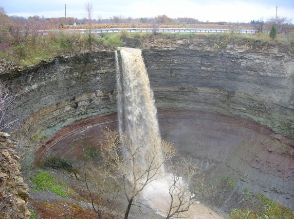
Devil's Punch Bowl
Canada
Height37 mWidth—
Also a block waterfall and of similar height
 Largest curtain
Victoria Falls
Zimbabwe · Zambia
Height108 mWidth1,708 m
Largest single sheet of falling water
 Tallest on earth
Angel Falls
Venezuela
Height979 mWidth—
 Widest on earth
Khone Phapheng Falls
Laos
Height21 mWidth10,783 m
Measured across the whole multi-channel system
Angel Falls is 22× taller than Dettifoss. Victoria Falls is 2.5× taller and 17× wider. Khone Phapheng Falls is 108× wider. Tallest · widest lists.
 2:22
 13:14
 4:25
Chosen from YouTube; videos belong to their creators and play from YouTube's privacy-enhanced player.
Walking guide
Paddy Dillon · 2015
Cicerone routes incl. the Fimmvörðuháls trek from Skógafoss, Skaftafell walks to Svartifoss and the Jökulsárgljúfur canyon by Dettifoss.
Guidebook
Lonely Planet · 2026
Newest Lonely Planet edition: Ring Road planning, road and weather advice, and practical detail for every major Icelandic waterfall.
Guidebook
Rough Guides · 2025
Current Rough Guide with region-by-region coverage of the south coast, Mývatn area, Snæfellsnes and Vatnajökull.

Guidebook
DK Eyewitness · 2024
Map-heavy illustrated guide, handy for picturing the Golden Circle and south-coast falls before you drive them.
The west bank is paved, open far more of the year, has better facilities and adds Selfoss, so it's the default. The east bank is closer to the drop, usually drier, and has the easier view of Hafragilsfoss, but its gravel Road 864 only opens from about June until the first autumn snow. With a summer car and time, see both.
Sometimes. Road 864 to the east bank is closed all winter, and Road 862 to the west bank gets limited snow clearing and can be shut for days or weeks, especially from January to early April. Check umferdin.is on the day. A super-jeep tour from Mývatn or Akureyri is the reliable option, and the frozen falls are worth the effort.
No. The river cuts the two viewpoints off from each other, and there's no bridge anywhere near the falls. To switch sides you drive back to the Ring Road and round — the two car parks are more than an hour apart by road — or north via Route 85 across the river near Ásbyrgi.
From the west-bank car park it's about a kilometre, 15 minutes each way over rocky ground, and the loop on to Selfoss and back is 2.5 km, about an hour. On the east bank the walk to the rim is around 10 minutes. The difficult 9 km Hafragil trail takes about four hours.
No. Entry and parking at both the west and east car parks were free as of late 2026, as were Ásbyrgi and Goðafoss. Vatnajökull National Park charges parking only at Skaftafell and Jökulsárlón. You'll pay for camping in the park, for parking at some Mývatn sights such as Hverir, and for the Vaðlaheiðargöng tunnel.
A roughly 250 km sightseeing loop in North Iceland: from Akureyri via Goðafoss and Lake Mývatn to Dettifoss, then north on the paved Road 862 to Ásbyrgi and round the coast through Húsavík. The final paved section of 862 opened in 2021, making it a proper circuit. It's doable in a long day but better over two or three.
At Dettifoss. The opening sequence of Ridley Scott's Prometheus (2012), in which a humanoid dissolves into a waterfall on a primordial Earth, was shot there, and the grey, churning water is exactly as it appears on screen. There's no film set or marker at the falls — just the view.
Not yet. Iceland is in the Schengen Area and most Western passport holders enter visa-free for up to 90 days in any 180-day period. ETIAS, the planned €20 pre-travel authorisation, has been delayed repeatedly through 2026 with no confirmed launch date — check before you fly rather than assuming it's live.
Dettifoss is in Iceland (Northeast Iceland), inside Vatnajökull National Park. The nearest base is Reykjahlíð (Mývatn) and the closest airport is AEY. Its coordinates are 65.8145, -16.3846.
Prices, fees and entry rules change. We re-check full guides regularly; spotted something out of date? Tell us.
Nearby

Historically tied to Iceland's conversion to Christianity

The Aldeyjarfoss waterfall is situated in the Highlands of Iceland at the northern part of the Sprengisandur…

Hengifoss is the third highest waterfall in Iceland, 128 meters. It is located in Hengifossá in…

Litlanesfoss is a waterfall in Hengifossá in Fljótsdalur, Eastern Iceland, also known as Stuðlabergsfoss .…