Lonely Planet Mexico (19th edition)Lonely Planet
Guidebook
Lonely Planet Mexico (19th edition)
Lonely Planet · 2025
Newest edition of the standard Mexico guide, covering Chiapas near Palenque, the Huasteca Potosina and Copper Canyon.

Mexico · San Lorenzo Albarradas Municipality
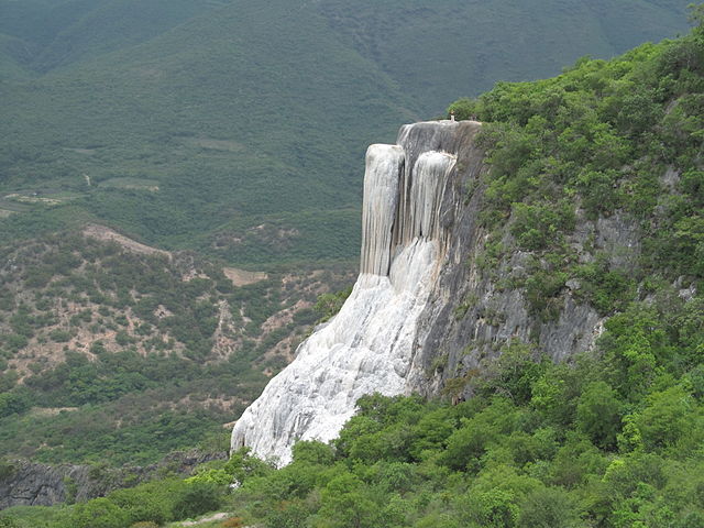
Hierve el Agua is a set of natural travertine rock formations in San Lorenzo Albarradas, Oaxaca, Mexico that resemble cascades of water.
Facts from Wikidata and Wikipedia, compiled September 2026; season and access are our estimate, not a visit report. How we build these pages.
Hierve el Agua drops over a series of steps. It is a cascade-type fall, and the nearest base for a visit is San Lorenzo Albarradas, Mexico. Access to the main viewpoint is rated moderate.
Summary adapted from the Wikipedia article (CC BY-SA 4.0).
As a cascade waterfall, water tumbles down a series of rock steps rather than falling free.
Also good forHikingPhotography
Fullest at the end of the wet season (October to December); the dry months of January to April are the easiest for swimming and access.
 This waterfall
Hierve el Agua
Mexico
Height—Width—
 Most similar
Agua Azul
Mexico
Height30 mWidth—
Also a cascade waterfall, with swimming and in Mexico too
 Largest curtain
Victoria Falls
Zimbabwe · Zambia
Height108 mWidth1,708 m
Largest single sheet of falling water
 Tallest on earth
Angel Falls
Venezuela
Height979 mWidth—
 Widest on earth
Khone Phapheng Falls
Laos
Height21 mWidth10,783 m
Measured across the whole multi-channel system
We don't have a reliable crest width for Hierve el Agua yet, so it is left off the width chart. Tallest · widest lists.
Guidebook
Lonely Planet · 2025
Newest edition of the standard Mexico guide, covering Chiapas near Palenque, the Huasteca Potosina and Copper Canyon.
16.86552, -96.276
Hierve el Agua is in Mexico (San Lorenzo Albarradas Municipality). The nearest base is San Lorenzo Albarradas, Mexico. Its coordinates are 16.8655, -96.2760.
Peak flow is January to February and October to December. Fullest at the end of the wet season (October to December); the dry months of January to April are the easiest for swimming and access.
Beyond the viewpoints: swimming, hiking and photography. Access to the main viewpoint is rated moderate — a real walk — expect stairs, uneven ground or an hour on the trail.
Yes — swimming is a normal part of a visit to Hierve el Agua, in the pools away from the falling water. Only swim where it is permitted on the day, stay clear of the base of the falls where currents recirculate, and skip it after heavy rain.
The usual base is San Lorenzo Albarradas, Mexico. A real walk — expect stairs, uneven ground or an hour on the trail from there.
Nearby

Eyipantla Falls is a waterfall located in the Los Tuxtlas region of southern Veracruz in Mexico. It is forty…
One of Mexico's most photographed natural swimming spots

The Basaltic Prisms of Santa María Regla are tall columnar joints of basalt rock near Huasca de Ocampo in the…

The Cascada de Misol-Há is a waterfall located in the Municipality of Salto de Agua, 20 kilometers from…