Lonely Planet Mexico (19th edition)Lonely Planet
Guidebook
Lonely Planet Mexico (19th edition)
Lonely Planet · 2025
Newest edition of the standard Mexico guide, covering Chiapas near Palenque, the Huasteca Potosina and Copper Canyon.

Mexico · Chiapas
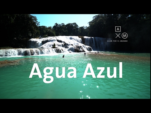
Cascadas de Agua Azul
A staircase of travertine terraces turns the river a milky turquoise-blue as calcium carbonate precipitates out of solution, forming dozens of natural swimming pools over several kilometres. It's a standard stop alongside the Palenque Maya ruins on Chiapas jungle circuits.
Checked September 2026 by David Bussell
Agua Azul drops 30 metres (98 ft) on the Xanil, inside Parque Nacional Agua Azul. It is a cascade-type fall, and the nearest base for a visit is Palenque, with PQM the closest airport. Access to the main viewpoint is rated easy.
As a cascade waterfall, water tumbles down a series of rock steps rather than falling free.
Also good forHikingPhotography
Dry season (Nov-Apr) keeps the travertine pools their signature turquoise; rains turn the water muddy brown.
Entry: Community entry fee ~$2-3 USD
 This waterfall
Agua Azul
Mexico
Height30 mWidth—
 Most similar
Issaqueena Falls
United States
Height30 mWidth—
Also a cascade waterfall, of similar height and in the United States
 Largest curtain
Victoria Falls
Zimbabwe · Zambia
Height108 mWidth1,708 m
Largest single sheet of falling water
 Tallest on earth
Angel Falls
Venezuela
Height979 mWidth—
 Widest on earth
Khone Phapheng Falls
Laos
Height21 mWidth10,783 m
Measured across the whole multi-channel system
Angel Falls is 33× taller than Agua Azul. Victoria Falls is 3.6× taller. We don't have a reliable crest width for Agua Azul yet, so it is left off the width chart. Tallest · widest lists.
 3:48
 9:14
 3:32
Chosen from YouTube; videos belong to their creators and play from YouTube's privacy-enhanced player.
Guidebook
Lonely Planet · 2025
Newest edition of the standard Mexico guide, covering Chiapas near Palenque, the Huasteca Potosina and Copper Canyon.
17.2547, -92.115
Agua Azul is in Mexico (Chiapas), inside Parque Nacional Agua Azul. The nearest base is Palenque and the closest airport is PQM. Its coordinates are 17.2547, -92.1150.
Agua Azul drops 30 metres (98 feet). It is a cascade-type waterfall on the Xanil.
Peak flow is January to April and November to December. Dry season (Nov-Apr) keeps the travertine pools their signature turquoise; rains turn the water muddy brown.
Beyond the viewpoints: swimming, hiking and photography. Access to the main viewpoint is rated easy — a short walk or roadside viewpoint.
Yes — swimming is a normal part of a visit to Agua Azul, in the pools away from the falling water. Only swim where it is permitted on the day, stay clear of the base of the falls where currents recirculate, and skip it after heavy rain.
The usual base is Palenque, and the closest airport is PQM. A short walk or roadside viewpoint from there. Community entry fee ~$2-3 USD.
Nearby

The Cascada de Misol-Há is a waterfall located in the Municipality of Salto de Agua, 20 kilometers from…

Big Rock Falls is a 150-foot waterfall on Privassion River, in the Mountain Pine Ridge Forest Reserve of the…

Thousand Foot Falls, also known as Hidden Valley Falls, is a waterfall and the centerpiece of a Belizean…

Eyipantla Falls is a waterfall located in the Los Tuxtlas region of southern Veracruz in Mexico. It is forty…