Lonely Planet BrazilTrent Holden et al.
Guidebook
Lonely Planet Brazil
Trent Holden et al. · 2025
Covers Foz do Iguaçu's panoramic side, Chapada Diamantina for Fumaça, and the Serra Gaúcha around Canela for Caracol.

Brazil · Bahia
Smoke Falls
Water free-falls off a sandstone tableland in Chapada Diamantina and, in a strong breeze, never reaches the canyon floor at all, dispersing into smoke-like mist that gives the falls their name. The clifftop viewpoint after a demanding hike looks straight down the full drop rather than at it from below.
Checked September 2026 by David Bussell
Cachoeira da Fumaça drops 340 metres (1,116 ft) on the Rio Capivara, inside Chapada Diamantina National Park. It is a plunge-type fall, and the nearest base for a visit is Vale do Capão, with SSA the closest airport. Access to the main viewpoint is rated hard.
Cachoeira da Fumaça is the tallest of the 14 waterfalls we cover in Brazil. As a plunge waterfall, water leaves the rock entirely and falls free through the air.
No commercial adventures run at Cachoeira da Fumaça itself — the experience is the approach and the view. Guided day trips from Vale do Capão are the easiest way to combine it with the area around it.
Also good forCampingHikingPhotography
Dry season (Apr-Sep) is best for the strenuous clifftop hike; heavy rains make the trail slick.
Entry: Park entry fee ~$5 USD
 This waterfall
Cachoeira da Fumaça
Brazil
Height340 mWidth—
 Most similar
Maria Jiray Falls
Peru
Height300 mWidth—
Also a plunge waterfall, of similar height and in Peru
 Largest curtain
Victoria Falls
Zimbabwe · Zambia
Height108 mWidth1,708 m
Largest single sheet of falling water
 Tallest on earth
Angel Falls
Venezuela
Height979 mWidth—
 Widest on earth
Khone Phapheng Falls
Laos
Height21 mWidth10,783 m
Measured across the whole multi-channel system
Angel Falls is 2.9× taller than Cachoeira da Fumaça. It drops 3.1× further than Victoria Falls (108 m). We don't have a reliable crest width for Cachoeira da Fumaça yet, so it is left off the width chart. Tallest · widest lists.
 31:54
 14:07
 10:24
Chosen from YouTube; videos belong to their creators and play from YouTube's privacy-enhanced player.
Guidebook
Trent Holden et al. · 2025
Covers Foz do Iguaçu's panoramic side, Chapada Diamantina for Fumaça, and the Serra Gaúcha around Canela for Caracol.

Guidebook
Ben Box · 2017
The one-volume continental handbook, useful for multi-country trips that link falls such as Iguazú, Kaieteur and Angel Falls.
-12.6007, -41.4551
Cachoeira da Fumaça is in Brazil (Bahia), inside Chapada Diamantina National Park. The nearest base is Vale do Capão and the closest airport is SSA. Its coordinates are -12.6007, -41.4551.
Cachoeira da Fumaça drops 340 metres (1,116 feet). It is a plunge-type waterfall on the Rio Capivara.
Peak flow is April to August. Dry season (Apr-Sep) is best for the strenuous clifftop hike; heavy rains make the trail slick.
Beyond the viewpoints: camping, hiking and photography. Access to the main viewpoint is rated hard — a serious approach: distance, altitude, a boat, or a guide.
The usual base is Vale do Capão, and the closest airport is SSA. A serious approach: distance, altitude, a boat, or a guide from there. Park entry fee ~$5 USD.
Nearby
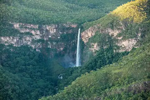
One of central Brazil's tallest waterfalls

Bahia Falls is a waterfall on the Santo Antônio River, in city of Santo Antônio do Rio Abaixo, in the state…

Chuvisco Falls is a waterfall on the Rio Preto in Minas Gerais, Brazil, on the boundary between the…

Toldi Falls is a waterfall located in the municipality of São Bento do Sapucaí, São Paulo, Brazil.