
Guidebook
Lonely Planet South Africa, Lesotho & Eswatini
James Bainbridge et al. · 2022
Covers the Drakensberg, Augrabies, KZN Midlands, Panorama Route falls and Lesotho's Semonkong for Maletsunyane in one book.

South Africa · Southern Africa
Aukoerebis
The Orange River funnels into a 240-metre granite gorge here, and the Khoi name meaning 'place of great noise' undersells how violently the water ricochets through the chasm. A fenced viewpoint lets you look straight down into the pothole-riddled ravine.
Checked September 2026 by David Bussell
Augrabies Falls drops 56 metres (184 ft) on the Orange, inside Augrabies Falls National Park. It is a cataract-type fall, and the nearest base for a visit is Kakamas, with UTN the closest airport. Access to the main viewpoint is rated easy.
As a cataract waterfall, a large, powerful waterfall or series of rapids on a big river.
No commercial adventures run at Augrabies Falls itself — the experience is the approach and the view. Guided day trips from Kakamas are the easiest way to combine it with the area around it.
Also good forHikingPhotographyWildlife & safari
Best after summer rains fill the Orange River catchment; dramatic flash floods possible March.
Entry: SANParks conservation fee
 This waterfall
Augrabies Falls
South Africa
Height56 mWidth—
 Most similar
Kairak falls
Kazakhstan
Height74 mWidth—
Also a cataract waterfall
 Largest curtain
Victoria Falls
Zimbabwe · Zambia
Height108 mWidth1,708 m
Largest single sheet of falling water
 Tallest on earth
Angel Falls
Venezuela
Height979 mWidth—
 Widest on earth
Khone Phapheng Falls
Laos
Height21 mWidth10,783 m
Measured across the whole multi-channel system
Angel Falls is 17× taller than Augrabies Falls. Victoria Falls is 1.9× taller. We don't have a reliable crest width for Augrabies Falls yet, so it is left off the width chart. Tallest · widest lists.
 7:24
 35:15
 8:31
Chosen from YouTube; videos belong to their creators and play from YouTube's privacy-enhanced player.
Guidebook
James Bainbridge et al. · 2022
Covers the Drakensberg, Augrabies, KZN Midlands, Panorama Route falls and Lesotho's Semonkong for Maletsunyane in one book.

Walking guide
Jeff Williams · 2017
Route descriptions for the Amphitheatre, including the Sentinel chain-ladder route to the top of Tugela Falls and the gorge walk below.
-28.5967, 20.3453
Augrabies Falls is in South Africa (Southern Africa), inside Augrabies Falls National Park. The nearest base is Kakamas and the closest airport is UTN. Its coordinates are -28.5967, 20.3453.
Augrabies Falls drops 56 metres (184 feet). It is a cataract-type waterfall on the Orange.
Peak flow is February to April. Best after summer rains fill the Orange River catchment; dramatic flash floods possible March.
Beyond the viewpoints: hiking, photography and wildlife & safari. Access to the main viewpoint is rated easy — a short walk or roadside viewpoint.
The usual base is Kakamas, and the closest airport is UTN. A short walk or roadside viewpoint from there. SANParks conservation fee.
Nearby
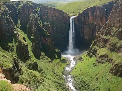
Longest single-drop abseil (204m) in the world
 Full guide
Among the world's tallest waterfalls (disputed second)

Ncandu Falls is a waterfall in the Ncandu River in Northern KwaZulu-Natal, in South Africa close to the town…

Magwa Falls is a waterfall in Eastern Cape province in South Africa. The main water drop is 142 metres .