
Guidebook
Lonely Planet South Africa, Lesotho & Eswatini
James Bainbridge et al. · 2022
Covers the Drakensberg, Augrabies, KZN Midlands, Panorama Route falls and Lesotho's Semonkong for Maletsunyane in one book.

South Africa · KwaZulu-Natal
Ncandu Falls is a waterfall in the Ncandu River in Northern KwaZulu-Natal, in South Africa close to the town of Newcastle, KwaZulu-Natal. Its name may mean "small flow" in Zulu or a Khosian language.
Facts from Wikidata and Wikipedia, compiled September 2026; season and access are our estimate, not a visit report. How we build these pages.
Ncandu Falls drops over a series of steps. It is a cascade-type fall, and the nearest base for a visit is Newcastle Local Municipality, South Africa. Access to the main viewpoint is rated moderate.
Summary adapted from the Wikipedia article (CC BY-SA 4.0).
As a cascade waterfall, water tumbles down a series of rock steps rather than falling free.
No commercial adventures run at Ncandu Falls itself — the experience is the approach and the view. Guided day trips from Newcastle Local Municipality are the easiest way to combine it with the area around it.
Also good forHikingPhotography
Summer rainfall in the east makes January to April the big-water months; the winter-rain Cape runs the other way.
 This waterfall
Ncandu Falls
South Africa
Height—Width—
 Most similar
Rusumo Falls
Rwanda · Tanzania
Height15 mWidth40 m
Also a cascade waterfall and in Rwanda
 Largest curtain
Victoria Falls
Zimbabwe · Zambia
Height108 mWidth1,708 m
Largest single sheet of falling water
 Tallest on earth
Angel Falls
Venezuela
Height979 mWidth—
 Widest on earth
Khone Phapheng Falls
Laos
Height21 mWidth10,783 m
Measured across the whole multi-channel system
We don't have a reliable crest width for Ncandu Falls yet, so it is left off the width chart. Tallest · widest lists.
Guidebook
James Bainbridge et al. · 2022
Covers the Drakensberg, Augrabies, KZN Midlands, Panorama Route falls and Lesotho's Semonkong for Maletsunyane in one book.

Walking guide
Jeff Williams · 2017
Route descriptions for the Amphitheatre, including the Sentinel chain-ladder route to the top of Tugela Falls and the gorge walk below.
-27.849, 29.844
Ncandu Falls is in South Africa (KwaZulu-Natal). The nearest base is Newcastle Local Municipality, South Africa. Its coordinates are -27.8490, 29.8440.
Peak flow is January to April. Summer rainfall in the east makes January to April the big-water months; the winter-rain Cape runs the other way.
Beyond the viewpoints: hiking and photography. Access to the main viewpoint is rated moderate — a real walk — expect stairs, uneven ground or an hour on the trail.
The usual base is Newcastle Local Municipality, South Africa. A real walk — expect stairs, uneven ground or an hour on the trail from there.
Nearby
 Full guide
Among the world's tallest waterfalls (disputed second)

KwaZulu-Natal's most accessible major waterfall
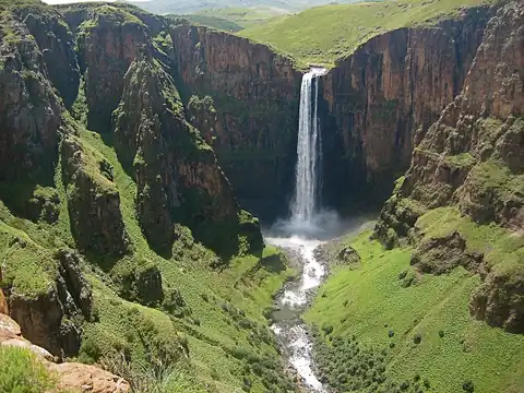
Longest single-drop abseil (204m) in the world

The Lone Creek Falls is near Sabie in Mpumalanga, South Africa. The waterfall plummets 70 m down into the…