
History & travel
Journey to the Shores of the Polar Sea in the Years 1819-20-21-22
John Franklin · 2001
Franklin's own narrative of the expedition that reached and named Wilberforce Falls on the Hood River in 1821.
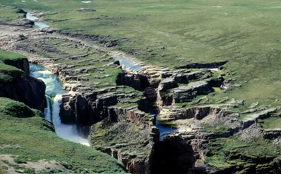
Canada · Kitikmeot Region, Nunavut
Kattimannap Qurlua
The Hood River drops about 49 metres in two steps into Wilberforce Gorge, a canyon some 3 km long and up to 76 metres deep cut into the Arctic tundra of Nunavut; the falls were officially renamed Kattimannap Qurlua in 2020. There is no road or trail, so visitors arrive by chartered floatplane or at the end of a two- to three-week canoe descent of the Hood, portaging around the gorge.
Checked September 2026 by David Bussell
Wilberforce Falls drops 49 metres (161 ft) on the Hood. It is a tiered-type fall, and the nearest base for a visit is Yellowknife, with YZF the closest airport. Access to the main viewpoint is rated hard.
Wilberforce Falls is number 6 on our list of waterfalls at the ends of the earth. As a tiered waterfall, a series of distinct drops, one below the other.
Also good forCampingHikingPhotographyWildlife & safari
The Hood is open to paddlers for only five to eight weeks after the ice goes out, so July and August are the practical window; canoe parties fly in by floatplane from Yellowknife.
Entry: No park fee; the real cost is a chartered floatplane from Yellowknife or a multi-week canoe expedition
 This waterfall
Wilberforce Falls
Canada
Height49 mWidth—
 Most similar
Tangle Falls
Canada
Height48 mWidth—
Also a tiered waterfall, of similar height and in Canada too
 Largest curtain
Victoria Falls
Zimbabwe · Zambia
Height108 mWidth1,708 m
Largest single sheet of falling water
 Tallest on earth
Angel Falls
Venezuela
Height979 mWidth—
 Widest on earth
Khone Phapheng Falls
Laos
Height21 mWidth10,783 m
Measured across the whole multi-channel system
Angel Falls is 20× taller than Wilberforce Falls. Victoria Falls is 2.2× taller. We don't have a reliable crest width for Wilberforce Falls yet, so it is left off the width chart. Tallest · widest lists.
 29:49
 1:01
Chosen from YouTube; videos belong to their creators and play from YouTube's privacy-enhanced player.
History & travel
John Franklin · 2001
Franklin's own narrative of the expedition that reached and named Wilberforce Falls on the Hood River in 1821.

Guidebook
Lonely Planet · 2024
Country-wide guide for combining Canadian falls, from Quebec and Ontario to the Rockies and the North.
67.0957, -108.7969
Wilberforce Falls is in Canada (Kitikmeot Region, Nunavut). The nearest base is Yellowknife and the closest airport is YZF. Its coordinates are 67.0957, -108.7969.
Wilberforce Falls drops 49 metres (161 feet). It is a tiered-type waterfall on the Hood.
Peak flow is July to August. The Hood is open to paddlers for only five to eight weeks after the ice goes out, so July and August are the practical window; canoe parties fly in by floatplane from Yellowknife.
Beyond the viewpoints: kayaking, camping, hiking, photography and wildlife & safari. Access to the main viewpoint is rated hard — a serious approach: distance, altitude, a boat, or a guide.
The usual base is Yellowknife, and the closest airport is YZF. A serious approach: distance, altitude, a boat, or a guide from there. No park fee; the real cost is a chartered floatplane from Yellowknife or a multi-week canoe expedition.
Nearby

Bloody Falls is a waterfall on the Coppermine River, in the Kugluk/Bloody Falls Territorial Park of Nunavut…

The Alexandra Falls is a 32 m waterfall located on the Hay River in the Northwest Territories. The falls, the…
 UNESCO
One of Canada's most remote major waterfalls

The High Level Bridge spans the North Saskatchewan River in Edmonton, Alberta, Canada. Opened as a bilevel…