
About this place
A Guide to New Zealand Waterfalls
Johnny T. Cheng · 2006
A guidebook devoted entirely to NZ waterfalls, with access notes; older, but still the only book on the subject.
New Zealand · Waikato, North Island
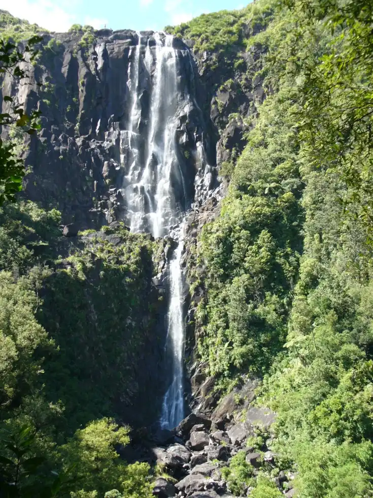
The North Island's tallest waterfall drops off the Kaimai Range in a single dramatic plunge, reached by a forest track that climbs steeply to a lookout roughly level with the top of the falls. It sits a short drive from Matamata, better known to many travelers as the real-world home of Hobbiton.
Checked September 2026 by David Bussell
Wairere Falls drops 153 metres (502 ft) on the Wairere Stream, inside Kaimai Mamaku Forest Park. It is a plunge-type fall, and the nearest base for a visit is Matamata, with HLZ the closest airport. Access to the main viewpoint is rated moderate.
As a plunge waterfall, water leaves the rock entirely and falls free through the air.
No commercial adventures run at Wairere Falls itself — the experience is the approach and the view. Guided day trips from Matamata are the easiest way to combine it with the area around it.
Also good forHikingPhotography
Spring and autumn give clear, mild conditions for the steep forest climb to the upper viewpoint.
Entry: Free
 This waterfall
Wairere Falls
New Zealand
Height153 mWidth—
 Most similar
Bowen Falls
New Zealand
Height162 mWidth—
Also a plunge waterfall, of similar height and in New Zealand too
 Largest curtain
Victoria Falls
Zimbabwe · Zambia
Height108 mWidth1,708 m
Largest single sheet of falling water
 Tallest on earth
Angel Falls
Venezuela
Height979 mWidth—
 Widest on earth
Khone Phapheng Falls
Laos
Height21 mWidth10,783 m
Measured across the whole multi-channel system
Angel Falls is 6.4× taller than Wairere Falls. It drops 1.4× further than Victoria Falls (108 m). We don't have a reliable crest width for Wairere Falls yet, so it is left off the width chart. Tallest · widest lists.
 8:15
 9:24
 11:58
Chosen from YouTube; videos belong to their creators and play from YouTube's privacy-enhanced player.
About this place
Johnny T. Cheng · 2006
A guidebook devoted entirely to NZ waterfalls, with access notes; older, but still the only book on the subject.
Guidebook
DK Eyewitness · 2024
Illustrated maps and regional chapters, helpful for planning a road trip between Taupo, Waitomo and Fiordland.
Guidebook
Jamie Christian Desplaces · 2024
Built around road trips and the Great Walks, a good fit if you're combining the Milford Track with North Island falls.

Guidebook
Lonely Planet · 2023
The 21st edition covers Fiordland, Milford Sound, Taupo and the Waikato, so it handles every NZ fall on this site.
-37.7342, 175.8796
Wairere Falls is in New Zealand (Waikato, North Island), inside Kaimai Mamaku Forest Park. The nearest base is Matamata and the closest airport is HLZ. Its coordinates are -37.7342, 175.8796.
Wairere Falls drops 153 metres (502 feet). It is a plunge-type waterfall on the Wairere Stream.
Peak flow is March to April and October to November. Spring and autumn give clear, mild conditions for the steep forest climb to the upper viewpoint.
Beyond the viewpoints: hiking and photography. Access to the main viewpoint is rated moderate — a real walk — expect stairs, uneven ground or an hour on the trail.
The usual base is Matamata, and the closest airport is HLZ. A real walk — expect stairs, uneven ground or an hour on the trail from there. Free.
Nearby

Owharoa Falls is a staircase waterfall in Waikato, New Zealand, located off Waitawheta Road in Karangahake…

Tarawera Falls is a 65 m high waterfall on the Tarawera River in the Bay of Plenty region in New Zealand's…

Kerosene Creek Waterfall is a waterfall in New Zealand.

A dramatic single-drop falls near Raglan's famous surf breaks