Walking in Southern NorwayUte Koninx
Walking guide
Walking in Southern Norway
Ute Koninx · 2021
Ten multi-day treks incl. Jotunheimen and Hardangervidda, the high country above Vettisfossen and Vøringsfossen.
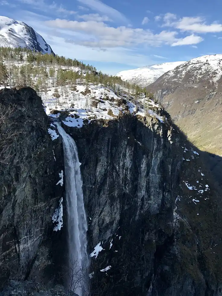
Norway · Jotunheimen
Norway's tallest unregulated waterfall — meaning no dam or hydro scheme has ever touched it — drops in a single free fall deep inside the Utladalen valley, reached only by a several-hour hike from the nearest road. Its protection since the 1880s makes it one of Europe's oldest deliberately conserved natural landmarks.
Checked September 2026 by David Bussell
Vettisfossen drops 275 metres (902 ft) on the Utla, inside Utladalen Landscape Protection Area. It is a plunge-type fall, and the nearest base for a visit is Ovre Ardal, with OSL the closest airport. Access to the main viewpoint is rated hard.
As a plunge waterfall, water leaves the rock entirely and falls free through the air.
No commercial adventures run at Vettisfossen itself — the experience is the approach and the view. Guided day trips from Ovre Ardal are the easiest way to combine it with the area around it.
Also good forCampingHikingPhotography
Summer glacial melt from Jotunheimen keeps the free fall at its fullest for the multi-hour hike in.
Entry: Free
 This waterfall
Vettisfossen
Norway
Height275 mWidth—
 Most similar
Valursfossen
Norway
Height272 mWidth—
Also a plunge waterfall, of similar height and in Norway too
 Largest curtain
Victoria Falls
Zimbabwe · Zambia
Height108 mWidth1,708 m
Largest single sheet of falling water
 Tallest on earth
Angel Falls
Venezuela
Height979 mWidth—
 Widest on earth
Khone Phapheng Falls
Laos
Height21 mWidth10,783 m
Measured across the whole multi-channel system
Angel Falls is 3.6× taller than Vettisfossen. It drops 2.5× further than Victoria Falls (108 m). We don't have a reliable crest width for Vettisfossen yet, so it is left off the width chart. Tallest · widest lists.
 11:17
 5:57
 3:50
Chosen from YouTube; videos belong to their creators and play from YouTube's privacy-enhanced player.
Walking guide
Ute Koninx · 2021
Ten multi-day treks incl. Jotunheimen and Hardangervidda, the high country above Vettisfossen and Vøringsfossen.

Guidebook
Lonely Planet · 2024
Current Lonely Planet covering the western fjords, Hardanger, Geiranger and Telemark roads past Norway's big falls.

Guidebook
DK Eyewitness · 2024
Illustrated Norway guide, good for planning fjord drives such as Geiranger and Hardanger.
61.3798, 7.946
Vettisfossen is in Norway (Jotunheimen), inside Utladalen Landscape Protection Area. The nearest base is Ovre Ardal and the closest airport is OSL. Its coordinates are 61.3798, 7.9460.
Vettisfossen drops 275 metres (902 feet). It is a plunge-type waterfall on the Utla.
Peak flow is June to August. Summer glacial melt from Jotunheimen keeps the free fall at its fullest for the multi-hour hike in.
Beyond the viewpoints: camping, hiking and photography. Access to the main viewpoint is rated hard — a serious approach: distance, altitude, a boat, or a guide.
The usual base is Ovre Ardal, and the closest airport is OSL. A serious approach: distance, altitude, a boat, or a guide from there. Free.
Nearby

Feigefossen is a waterfall in Norway.

Rjukandefossen is a double waterfall of approximately 18 metres located in the vicinity of the village Tuv in…

Ramnefjellsfossen is unofficially listed as the third-highest waterfall in the world in several publications.…

Kvinnefossen is a waterfall of the river Kvinna in Sogndal Municipality in Vestland county, Norway. County…