Lonely Planet ThailandLonely Planet
Guidebook
Lonely Planet Thailand
Lonely Planet · 2024
The 19th edition covers Kanchanaburi for Erawan and the Tak and Mae Sot area near Pha Charoen.
Thailand · Kaeng Sopha
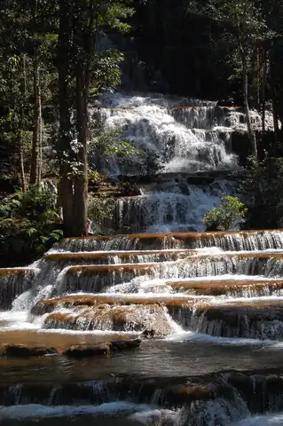
Namtok Kaeng Sopha is a waterfall in Wang Thong District, Phitsanulok Province, Thailand. It is in Thung Salaeng Luang National Park on the Wang Thong River off of Lomsak Road .
Facts from Wikidata and Wikipedia, compiled September 2026; season and access are our estimate, not a visit report. How we build these pages.
Namtok Kaeng Sopha drops over a series of steps on the Wang Thong River, inside Thung Salaeng Luang National Park. It is a tiered-type fall, and the nearest base for a visit is Ban Yaeng, Thailand. Access to the main viewpoint is rated moderate.
Summary adapted from the Wikipedia article (CC BY-SA 4.0).
As a tiered waterfall, a series of distinct drops, one below the other.
No commercial adventures run at Namtok Kaeng Sopha itself — the experience is the approach and the view. Guided day trips from Ban Yaeng are the easiest way to combine it with the area around it.
Also good forHikingPhotographyWildlife & safari
Wet-season fed: fullest from August to December; by March and April many falls here are a trickle.
 Most similar
Barehipani Falls
India
Height—Width—
Also a tiered waterfall and in India
 Largest curtain
Victoria Falls
Zimbabwe · Zambia
Height108 mWidth1,708 m
Largest single sheet of falling water
 Tallest on earth
Angel Falls
Venezuela
Height979 mWidth—
 Widest on earth
Khone Phapheng Falls
Laos
Height21 mWidth10,783 m
Measured across the whole multi-channel system
We don't have a reliable crest width for Namtok Kaeng Sopha yet, so it is left off the width chart. Tallest · widest lists.
Guidebook
Lonely Planet · 2024
The 19th edition covers Kanchanaburi for Erawan and the Tak and Mae Sot area near Pha Charoen.
Guidebook
Rough Guides · 2024
For a multi-country trip, one book covering the overland routes between the Southeast Asian falls on this site.
16.87111, 100.83528
Namtok Kaeng Sopha is in Thailand (Kaeng Sopha), inside Thung Salaeng Luang National Park. The nearest base is Ban Yaeng, Thailand. Its coordinates are 16.8711, 100.8353.
Peak flow is August to December. Wet-season fed: fullest from August to December; by March and April many falls here are a trickle.
Beyond the viewpoints: hiking, photography and wildlife & safari. Access to the main viewpoint is rated moderate — a real walk — expect stairs, uneven ground or an hour on the trail.
The usual base is Ban Yaeng, Thailand. A real walk — expect stairs, uneven ground or an hour on the trail from there.
Nearby

Namtok Kaeng Song is a waterfall in the Wang Thong District of Phitsanulok Province in Thailand. It is on the…

Namtok Si Dit is a waterfall and tourist attraction in Thailand. The waterfall is on the Wang Thong River and…
A remote highlight of Thailand's far western borderlands

The Thi Lo Su Waterfall is claimed to be the largest and highest waterfall in Thailand. It stands 250 metres…