Lonely Planet ThailandLonely Planet
Guidebook
Lonely Planet Thailand
Lonely Planet · 2024
The 19th edition covers Kanchanaburi for Erawan and the Tak and Mae Sot area near Pha Charoen.
Thailand · Tak
น้ำตกพาเจริญ
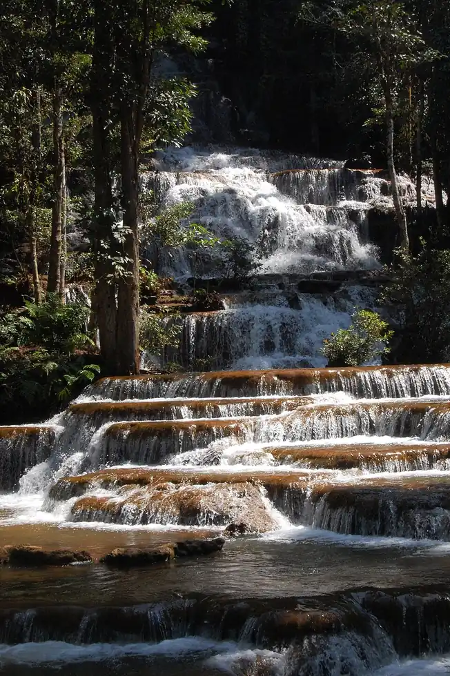
Multiple broad limestone shelves step the Mae Charoen stream down a forested hillside near the remote Thai-Myanmar border town of Umphang, each tier forming its own shallow swimming pool. It sees a fraction of the visitors of Thailand better-known falls thanks to the long, winding mountain drive required to reach it.
Checked September 2026 by David Bussell
Pha Charoen Falls drops over a series of steps on the Mae Charoen, inside Namtok Pha Charoen National Park. It is a tiered-type fall, and the nearest base for a visit is Mae Sot. Access to the main viewpoint is rated moderate.
As a tiered waterfall, a series of distinct drops, one below the other.
Also good forHikingPhotography
Cool dry season gives clear water over the wide limestone shelves.
Entry: Park entry ~100 THB
 This waterfall
Pha Charoen Falls
Thailand
Height—Width—
 Most similar
Erawan Falls
Thailand
Height—Width—
Also a tiered waterfall, with swimming and in Thailand too
 Largest curtain
Victoria Falls
Zimbabwe · Zambia
Height108 mWidth1,708 m
Largest single sheet of falling water
 Tallest on earth
Angel Falls
Venezuela
Height979 mWidth—
 Widest on earth
Khone Phapheng Falls
Laos
Height21 mWidth10,783 m
Measured across the whole multi-channel system
We don't have a reliable crest width for Pha Charoen Falls yet, so it is left off the width chart. Tallest · widest lists.
 3:15
 3:27
 14:04
Chosen from YouTube; videos belong to their creators and play from YouTube's privacy-enhanced player.
Guidebook
Lonely Planet · 2024
The 19th edition covers Kanchanaburi for Erawan and the Tak and Mae Sot area near Pha Charoen.
Guidebook
Rough Guides · 2024
For a multi-country trip, one book covering the overland routes between the Southeast Asian falls on this site.
16.5023, 98.7529
Pha Charoen Falls is in Thailand (Tak), inside Namtok Pha Charoen National Park. The nearest base is Mae Sot. Its coordinates are 16.5023, 98.7529.
Peak flow is January to February and November to December. Cool dry season gives clear water over the wide limestone shelves.
Beyond the viewpoints: swimming, hiking and photography. Access to the main viewpoint is rated moderate — a real walk — expect stairs, uneven ground or an hour on the trail.
Yes — swimming is a normal part of a visit to Pha Charoen Falls, in the pools away from the falling water. Only swim where it is permitted on the day, stay clear of the base of the falls where currents recirculate, and skip it after heavy rain.
The usual base is Mae Sot. A real walk — expect stairs, uneven ground or an hour on the trail from there. Park entry ~100 THB.
Nearby

The Thi Lo Su Waterfall is claimed to be the largest and highest waterfall in Thailand. It stands 250 metres…

Namtok Kaeng Song is a waterfall in the Wang Thong District of Phitsanulok Province in Thailand. It is on the…

Mae Ya Waterfall is a waterfall in Doi Inthanon National Park, Chom Thong District, Chiang Mai province…

Wachirathan Falls are waterfalls in the Chom Thong district in the province of Chiang Mai, Thailand.