Lonely Planet ColombiaAlex Egerton et al.
Guidebook
Lonely Planet Colombia
Alex Egerton et al. · 2025
Current Colombia guide with Bogotá and Cundinamarca day trips, the base for Tequendama and La Chorrera.
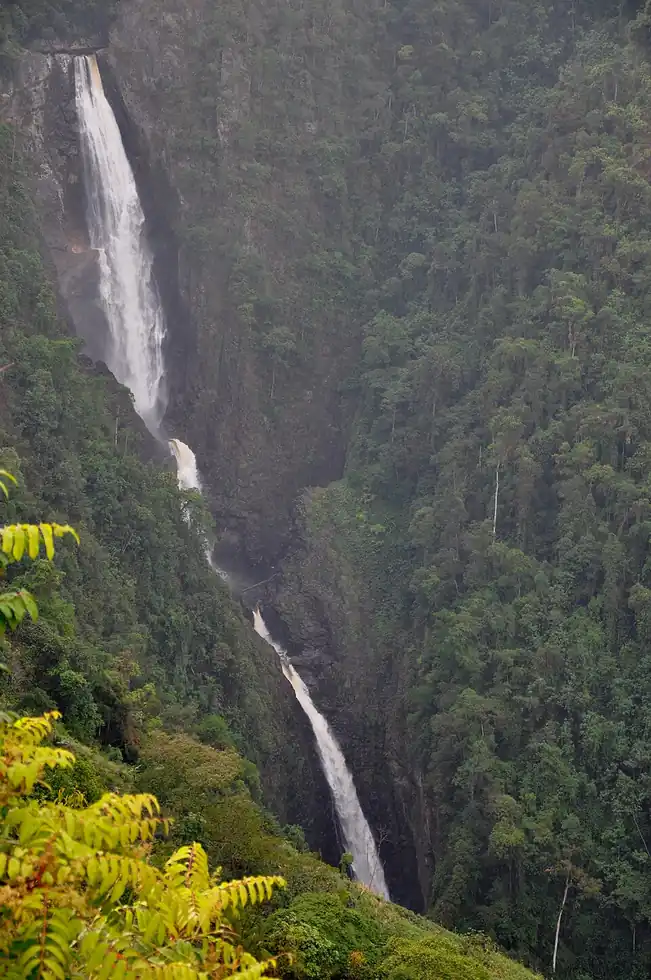
Colombia · Cundinamarca
Colombia's tallest waterfall drops in multiple tiers down a cloud-forest escarpment near Choachí, reachable only with a certified local guide on a steep, rope-assisted trail. It remained relatively obscure until the mid-2010s, when improved trail access opened it to day-trippers from Bogotá.
Checked September 2026 by David Bussell
La Chorrera drops 590 metres (1,936 ft) on the Río Bogotá tributary, inside Chicaque Natural Park area. It is a tiered-type fall, and the nearest base for a visit is Choachí, with BOG the closest airport. Access to the main viewpoint is rated hard.
La Chorrera is the tallest of the 4 waterfalls we cover in Colombia. As a tiered waterfall, a series of distinct drops, one below the other.
No commercial adventures run at La Chorrera itself — the experience is the approach and the view. Guided day trips from Choachí are the easiest way to combine it with the area around it.
Also good forHikingPhotography
Dry windows (Dec-Feb, Jul) give the safest footing on the steep descent.
Entry: Guided tour fee required, ~$20-30 USD
 This waterfall
La Chorrera
Colombia
Height590 mWidth—
 Most similar
Cuquenan Falls
Venezuela
Height674 mWidth—
Also a tiered waterfall, of similar height and in Venezuela
 Largest curtain
Victoria Falls
Zimbabwe · Zambia
Height108 mWidth1,708 m
Largest single sheet of falling water
 Tallest on earth
Angel Falls
Venezuela
Height979 mWidth—
 Widest on earth
Khone Phapheng Falls
Laos
Height21 mWidth10,783 m
Measured across the whole multi-channel system
Angel Falls is 1.7× taller than La Chorrera. It drops 5.5× further than Victoria Falls (108 m). We don't have a reliable crest width for La Chorrera yet, so it is left off the width chart. Tallest · widest lists.
 10:35
 8:35
 11:14
Chosen from YouTube; videos belong to their creators and play from YouTube's privacy-enhanced player.
Guidebook
Alex Egerton et al. · 2025
Current Colombia guide with Bogotá and Cundinamarca day trips, the base for Tequendama and La Chorrera.

Guidebook
Ben Box · 2017
The one-volume continental handbook, useful for multi-country trips that link falls such as Iguazú, Kaieteur and Angel Falls.
4.4667, -74.2833
La Chorrera is in Colombia (Cundinamarca), inside Chicaque Natural Park area. The nearest base is Choachí and the closest airport is BOG. Its coordinates are 4.4667, -74.2833.
La Chorrera drops 590 metres (1,936 feet). It is a tiered-type waterfall on the Río Bogotá tributary.
Peak flow is January to February and July and December. Dry windows (Dec-Feb, Jul) give the safest footing on the steep descent.
Beyond the viewpoints: hiking and photography. Access to the main viewpoint is rated hard — a serious approach: distance, altitude, a boat, or a guide.
The usual base is Choachí, and the closest airport is BOG. A serious approach: distance, altitude, a boat, or a guide from there. Guided tour fee required, ~$20-30 USD.
Nearby

Colombia's most famous, and most polluted, waterfall

Tequendamita Falls is a small natural waterfall in Colombia located in the municipality of El Retiro, in the…

San Rafael Falls was a waterfall on the Coca River in Sucumbíos and Napo, Ecuador. Standing 131 metres high…

Cascada del Vino is a Venezuelan water fall with the peculiar feature that the river has a tinged of…